Geography.
 The Canary archipelago is located in the Atlantic Ocean only 115 kilometres from the African coastline ( Cape Juby) and 1 050 kilometres from Cádiz.
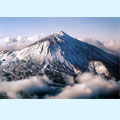
It is made up of seven large islands and three smaller islands as well as many isles. The larger islands are Tenerife, Gran Canaria, Lanzarote, Fuerteventura, La Palma, Hierro and Gomera . These islands are of volcanic origin. This is the home of the Teide volcano, which is active, and is 3 711 metres above sea level. It is considered the highest point in Spain.
The climate is tropical, varying with altitude. There is scarce rainfall and due to its relative closeness to the Tropic of  Cancer these islands could be authentic deserts, but the mountainous character of some of them as well as the climate make for abundant vegetation in the humid areas. Nevertheless, Lanzarote and Fuerteventura can be considered as deserts, while La Palma is humid.
In all the territories, the visitor’s stay is pleasant because the sunny climate is considered a piece of summer all year round.